What a trip out to Montana. Incredible country and we hiked some amazing trails! Here's a two minute video of our vacation.

Showing posts with label hiking. Show all posts
Showing posts with label hiking. Show all posts
Monday, August 21, 2023
Monday, November 9, 2020
Mt. Moosilauke - November 8, 2020
My wife and I spent the weekend in the Whites, spending Saturday hiking Mt. Moriah (separate report coming for that one). We stayed in Plymouth on Saturday night and I snuck out of the hotel in the wee hours and made the 30 minute drive to the Glencliff trailhead. I've never been up Moosilauke from this trail and figured it shouldn't be too hard to follow with a headlamp. I was correct although I still managed to go off trail once or twice as one does in the dark. Originally I didn't think I'd make it up for sunrise but I was making good time and started to push when I realized I was on target. There was a one short section of Glencliff that was fairly icy, making me regret my lack of spikes momentarily, but it was short lived.
Once I reached Carriage Rd I could see the spectacular sunrise poking through the trees. I pushed as fast as I could in order to get above treeline before the colors faded. I didn't encounter any more ice - just a lot of mud. I was able to get my look at the sunrise which was splendid. I continued on to the summit which ended up being more overcast than anything. But the weather was so warm that I was able to throw on my synthetic jacket and linger up there for twenty minutes despite the steady breeze and being in shorts. The last time on Moosilauke it was a bit of a zoo so having the summit to myself was a nice treat.
Originally I had planned to just descend Glencliff but I was doing well on time so I decided to head down Carriage Rd and take the Hurricane trail back to the car. There was one brief section of snow/ice on Carriage Rd but otherwise the trail was fairly dry. And a joy to run down. Hurricane trail had a couple peaceful streams and a partially obstructed viewpoint at height of land. This trail was marked well by blue blazes which I was thankful for as it was a little tough to follow with recent heavy leaf cover.
Happy to fit this one in before heading home. After showering and checking out we still had time for a tasty outdoor breakfast at the Main Street Diner (maybe the best homefries I've had). See below for a short video of my hike!
Tuesday, October 13, 2020
Whiteface and Passaconaway - Wrapping Up Round 2
Went up the the Whites this past weekend and wrapped up my second round of the 4000 footers. I had two left - Whiteface and Carrigain. First up was Whiteface which I did along with Passaconaway. I had wanted to get up there at least once this fall for the foliage but it came and went so fast this year due to drought conditions that most of the higher leaves were already gone. Still beautiful especially since the yellow birch leaves were popping. Here's the video of my first hike.
Saturday, March 4, 2017
The Bonds and Twins Backpacking Trip - May 20 & 21, 2016
Note: This trip report is horribly late. A draft has been sitting amongst my other blog reports for the past eight months. With another group backpacking trip a few months away, I felt compelled to get this one finished.
My friend the Manchild let me know that he and his friends were preparing to do a two day hike in the Pemi wilderness, camping at the Guyot campsite. He invited me along and I was happy to get another chance to backpack in New Hampshire. I had done much of this hike last October but with spring conditions and new companions I knew it would be a completely different hike. This would be a two day janut, starting at Lincoln Woods and heading out through the Twins.
Besides my friend Rob I'd be hiking with Duncan, Derek and Pete. I drove up Thursday night and stayed at Duncan's cabin which was conveniently located just north of Franconia. They had already dropped off a spot car that night so in the morning all we had to do was load up one car and head to the Lincoln Woods parking lot. We got a respectable 7 AM start. It was chilly at first but I warmed up soon as we started moving.

The first several miles of trail are an old rail bed and get boring after a while. It was nice hiking with other people and it made these dull miles pass faster. Once the trail began to climb a clear pecking order was established, with Duncan and myself often hiking up ahead before waiting for the other guys. The weather was warm and clear and when we reached the summit of Bondcliff we were treated to stellar views. We all took turns getting our picture taken on the famous cliff but Christ it was terrifying out there.
After a rest at Bondcliff we climbed the next short steep section to Mt Bond. Other hikers began to pass us on their way up at this point. As is my habit I was nervous about the Guyot campsite filling up but when we arrived at 2 PM there was still plenty of room. Only one of the platforms was taken and there a couple bags in the shelter. I set up my tent on the platform above the shelter, offering fine views of my domain. Derek set up on a platform nearby and Duncan and Derek set up shop in the shelter. The Manchild set up a hammock next to my platform.
After setting up camp and relaxing, we ventured out to hike up to West Bond. Another fellow who was hiking the loop by himself joined us. This short hike was much more pleasant without the heavy pack. We hung at the summit for a while, enjoying the late afternoon. Once back at camp we cooked dinner on our various little stoves at my tent platform. By now it was late in the day and the camp was filling up. There was a group of boarding school girls that filled up the shelter. All the platforms had now been claimed by various groups. Derek gave up his platform to another couple and the guys carried his tent and placed it next to mine.
The next morning we made our breakfasts, packed up our gear and ventured out. All it took was the climb up from the Guyot Campsite to make my back ache. It was going to be a long day! The ridgeline along to South Twin held some remaining rotten snow and microspikes were a big help here. The views at South Twin were stellar and we spent a bit of time here enjoying the day.
After we passed North Twin and began to descend we encountered many people heading up the trail. A mix of snow/mud near the top made things slick but once we got lower the snow disappeared. We ran into one woman who had to park at Route 3 as Haystack Road was still closed. But just as she finished the two mile walk to the trailhead some cars went by. They opened the road just after she started out. What a drag! Once the trail flattened out we had to deal with a tough water crossing. The river was high so there was no choice but to just ford it.
Tired and with heavy packs, we finally made it to the trailhead. Now was the tricky part. Since Haystack Road had been closed, the guys had spotted a car on the nearby Little River Road. Maps showed that if we bushwacked along Little River we'd reach the car. Thus began our final odyssey. It was a slow march through the woods and brush. We were on a steep hill for much of it before getting down onto the river rocks and scrambling along them. Everyone was ready to be done but everyone kept their grumpiness to themselves. After what seemed like forever, we reached the car and the end of our journey.
Like I said I wrote much of this quite a while ago but I just wrote the Day 2 stuff which is why it's so sparse. However I must say this was a great trip with a terrific group of guys. I'm glad they thought to invite me - looking forward to more such adventures with them!
My friend the Manchild let me know that he and his friends were preparing to do a two day hike in the Pemi wilderness, camping at the Guyot campsite. He invited me along and I was happy to get another chance to backpack in New Hampshire. I had done much of this hike last October but with spring conditions and new companions I knew it would be a completely different hike. This would be a two day janut, starting at Lincoln Woods and heading out through the Twins.
Besides my friend Rob I'd be hiking with Duncan, Derek and Pete. I drove up Thursday night and stayed at Duncan's cabin which was conveniently located just north of Franconia. They had already dropped off a spot car that night so in the morning all we had to do was load up one car and head to the Lincoln Woods parking lot. We got a respectable 7 AM start. It was chilly at first but I warmed up soon as we started moving.
 |
| Our adventure begins - Photo by Duncan Ross |
 |
| The long, long Lincoln Woods trail |
 |
| Nearly to Bondcliff summit - Photo by Duncan Ross |
 |
| The last scramble to the top of Bondcliff |
 |
| This was as close to the edge as I dared Photo by Duncan Ross |

 |
| Heading towards Mt Bond - Photo by Duncan Ross |
The first several miles of trail are an old rail bed and get boring after a while. It was nice hiking with other people and it made these dull miles pass faster. Once the trail began to climb a clear pecking order was established, with Duncan and myself often hiking up ahead before waiting for the other guys. The weather was warm and clear and when we reached the summit of Bondcliff we were treated to stellar views. We all took turns getting our picture taken on the famous cliff but Christ it was terrifying out there.
After a rest at Bondcliff we climbed the next short steep section to Mt Bond. Other hikers began to pass us on their way up at this point. As is my habit I was nervous about the Guyot campsite filling up but when we arrived at 2 PM there was still plenty of room. Only one of the platforms was taken and there a couple bags in the shelter. I set up my tent on the platform above the shelter, offering fine views of my domain. Derek set up on a platform nearby and Duncan and Derek set up shop in the shelter. The Manchild set up a hammock next to my platform.
 |
| The always opportunistic gray jay - Photo by Duncan Ross |
 |
| Setting up camp at Guyot - Photo by Peter Boudreau |
 |
| Relaxin' in style on our pimped out platform |
 |
| Enjoying the sunset on West Bond |
 |
| Breakfast in the Guyot "kitchen" |
The next morning we made our breakfasts, packed up our gear and ventured out. All it took was the climb up from the Guyot Campsite to make my back ache. It was going to be a long day! The ridgeline along to South Twin held some remaining rotten snow and microspikes were a big help here. The views at South Twin were stellar and we spent a bit of time here enjoying the day.
After we passed North Twin and began to descend we encountered many people heading up the trail. A mix of snow/mud near the top made things slick but once we got lower the snow disappeared. We ran into one woman who had to park at Route 3 as Haystack Road was still closed. But just as she finished the two mile walk to the trailhead some cars went by. They opened the road just after she started out. What a drag! Once the trail flattened out we had to deal with a tough water crossing. The river was high so there was no choice but to just ford it.
 |
| The rocky exposed section near Mt Guyot - Photo by Duncan Ross |
 |
| Slippery snow along the ridgeline - Photo by Duncan Ross |
 |
| Mt Garfield in the distance from South Twin summit - Photo by Duncan Ross |
 |
| Top o' South Twin |
 |
| One last chance for views near the summit of North Twin Photo by Rob Ragazzo |
 |
| Rob makes the tricky water crossing |
Tired and with heavy packs, we finally made it to the trailhead. Now was the tricky part. Since Haystack Road had been closed, the guys had spotted a car on the nearby Little River Road. Maps showed that if we bushwacked along Little River we'd reach the car. Thus began our final odyssey. It was a slow march through the woods and brush. We were on a steep hill for much of it before getting down onto the river rocks and scrambling along them. Everyone was ready to be done but everyone kept their grumpiness to themselves. After what seemed like forever, we reached the car and the end of our journey.
Like I said I wrote much of this quite a while ago but I just wrote the Day 2 stuff which is why it's so sparse. However I must say this was a great trip with a terrific group of guys. I'm glad they thought to invite me - looking forward to more such adventures with them!
Thursday, April 14, 2016
South Carter and Mt Hight - March 20, 2016
This was the second hike of a weekend trip to the White Mountains. The first hike was a fun trip to the Hancocks with my friend Rob. This one would be a solo affair. I had originally considered attempting Mt Isolation however upon reflecting it seemed like too much. It would have been 14 miles round trip and I had a five hour drive home afterwards. Plus there was word of a snow storm hitting RI at some point in the evening so I didn't want to linger too long in NH. After pouring over the map the night before at my hostel, I opted for a shorter hike. I decided to head up the 19 Mile Brook trail and summit South Carter. Based on how long it would take, I could also head over to Mt. Hight as well before coming back down.
I got an early start and was on the trail by 7 AM. At first it was mostly dirt and I barebooted. There were plenty of icy patches but most were easily avoided. At 3/4 mile I decided to put on the microspikes for a tricky ledge section but I left 'em on - should've removed them as there was plenty of dirt over the next mile. By the time I turned onto the Carter Dome Trail at mile 2 it was mostly ice/snow and the spikes stayed on. There was a tricky water crossing on this trail and one tough ice dam to climb over but otherwise the trail was easy going.
The trail leads up to Zeta Pass and after a short break I made the quick trip to South Carter. There are no views on South Carter. It's totally forested but it's another 4k checked off. I arrived back at Zeta Pass with plenty of time left so it was an easy decision to head up to Mt. Hight. The trail up to Hight was much less traveled and the snow was much deeper. The trail itself was steep and between the grade and the snow it was slow going. It was only about a 1/3 mile of this climb and then the trail opened up to the bare summit of Mt. Hight.
Incredible 360 views on Hight and I hung out a while and ate lunch. Then it was a quick trip back down to Zeta Pass. The last four miles were an easy grade and I finally saw other people for the first time. I probably passed about 30 people heading up on the way down. Towards the bottom I encountered some folks a good mile into the trail who were clearly not expecting so much ice. Sorry folks, still too early! This was a fun hike and I covered the ten miles in just over five hours which I was happy with. The drive home wasn't too bad and the snow never really showed up that evening.
This was NH 4k #33 for me.
I got an early start and was on the trail by 7 AM. At first it was mostly dirt and I barebooted. There were plenty of icy patches but most were easily avoided. At 3/4 mile I decided to put on the microspikes for a tricky ledge section but I left 'em on - should've removed them as there was plenty of dirt over the next mile. By the time I turned onto the Carter Dome Trail at mile 2 it was mostly ice/snow and the spikes stayed on. There was a tricky water crossing on this trail and one tough ice dam to climb over but otherwise the trail was easy going.
 |
| Nice bridge set up to cross the 19 Mile Brook |
 |
| Frozen beauty on the water |
 |
| Mt Hight featured the only real steep/snow of the day |
The trail leads up to Zeta Pass and after a short break I made the quick trip to South Carter. There are no views on South Carter. It's totally forested but it's another 4k checked off. I arrived back at Zeta Pass with plenty of time left so it was an easy decision to head up to Mt. Hight. The trail up to Hight was much less traveled and the snow was much deeper. The trail itself was steep and between the grade and the snow it was slow going. It was only about a 1/3 mile of this climb and then the trail opened up to the bare summit of Mt. Hight.
 |
| Northern presidentials in the background |
 |
| Enough snow on the summit to still feel like winter |
 |
| Mount Washington |
 |
| Hard to tell but the brook was a great mix of churning water and ice |
Incredible 360 views on Hight and I hung out a while and ate lunch. Then it was a quick trip back down to Zeta Pass. The last four miles were an easy grade and I finally saw other people for the first time. I probably passed about 30 people heading up on the way down. Towards the bottom I encountered some folks a good mile into the trail who were clearly not expecting so much ice. Sorry folks, still too early! This was a fun hike and I covered the ten miles in just over five hours which I was happy with. The drive home wasn't too bad and the snow never really showed up that evening.
This was NH 4k #33 for me.
Wednesday, March 23, 2016
Mt Hancock and South Hancock - March 19, 2016
I'm on the DL with the ankle stress fracture and that means no running. However walking/hiking doesn't hurt so that's fair game. Amanda suggested I plan a trip north so that I don't go stir crazy. She thought I'd plan it for the next month or two when the weather warms but I was excited to get up there while there was still snow and make use of my new winter gear one more time. I scrapped the idea of an overnight as it was still too cold for that (which was wise as it ended up being mid-teens in the valley on Saturday night). Instead I opted for two day hikes. The first would be a trip to bag the Hancocks. This ten mile hike off the Kancamagus Highway is fairly moderate until you get close to the peaks.
I stayed with my friend Rob aka the Manchild on Friday night and he was game to join me on Saturday. A trip report from the week prior indicated a lot of ice on the steep sections which had me a little worried but we steeled each other and were ready to give it a shot. It was a gorgeous bluebird day with temps in the 30s. The trail was immediately snow with a bit of ice. It became more and more ice as it wore on. We wore our microspikes almost immediately. The first few miles were an easy hike through Hancock Notch. Then we had to deal with a couple water crossings. The streams were running fairly high and there was still plenty of ice on the rocks. The first few were tricky and we bushwacked a bit to find the best place to cross.
At about 2.5 miles we hit the Hancock Loop Trail and after a tough water crossing the trail began to climb. We passed a group of three guys that we would leapfrog with for the next few hours. The Manchild's cheap knockoff microspikes broke a couple chainlinks but luckily I had brought my leatherman with pliers. He mended them as best they could but they were soon janked up again. At the point where the trail splits in two and loops over both peaks, Rob stopped to work on them again. A woman came down the south trail in crampons and told us not to head down the south side with just microspikes. Apparently people had been buttsliding and it was sheer ice in many spots. She was kind enough to provide Rob with some zipties (a great idea!) and once again his janked up spikes were back in business.
Heading her advice, we went up the south trail and would come down the north. The next mile was slow slow slow. It was a little bit of snow over mostly ice and the trail was very steep. The microspikes actually worked well. We just had to choose our spots carefully. A couple faster groups passed us and it was tricky finding places to stand to let them by. The heel of one of Rob's spikes was now good and useless but he could still use the front for traction. Finally we got to the summit of South Hancock and enjoyed a great view of Mt Carrigan, Attitash and the Moats.
The 1.4 mile trail between the summits was moderate and provided some shelter from the wind which hounded us on the summit. The trail was wellpacked snow but if you stepped off the trail you postholed about two feet down. We stopped for lunch and the Manchild fired up his stove to whip up chili mac and hot chocolate. Those three guys passed us again while we ate. Once we got going we soon passed them again for the last time. Not long after we reached the summit of Hancock. Great views of the Sandwich range.
Now it was time to descend. The north trail was longer than south but not quite as steep. There were also some muddy sections near the top where the sun had been at work. We passed a few groups heading up and they'd be the last people we'd see all day. One of the Manchild's jerryrigged microspikes finally gave up the ghost. He now had only one tractioned foot to work with and the going was tough. Once the trail became all snow/ice again he went with the buttsliding technique, using his feet to steer and break. It was something to see. The other microspike blew out on his first slide and now he had no choice but to continue this way. By the end he ripped a big hole in his pants but otherwise seemed no worse for wear.
When we got back to the intersection the Manchild had a much easier time of it though he still had to watch his step on the icier sections. The rest of the hike was without incident. After making it over the final water crossing we relaxed and enjoyed the rest of the hike back to the cars. I'm glad Rob was able to join me. It made the day much longer but I was glad for the company. I'm also glad that the trails weren't as treacherous as previous trip reports had led me to believe. Thankfully the microspikes were good enough. Well, mine anyway. The Manchild learned a valuable lesson about investing in quality traction.
This was NH 4k #31 & 32 for me. It was winter 4k #2 & 3.
I stayed with my friend Rob aka the Manchild on Friday night and he was game to join me on Saturday. A trip report from the week prior indicated a lot of ice on the steep sections which had me a little worried but we steeled each other and were ready to give it a shot. It was a gorgeous bluebird day with temps in the 30s. The trail was immediately snow with a bit of ice. It became more and more ice as it wore on. We wore our microspikes almost immediately. The first few miles were an easy hike through Hancock Notch. Then we had to deal with a couple water crossings. The streams were running fairly high and there was still plenty of ice on the rocks. The first few were tricky and we bushwacked a bit to find the best place to cross.
 |
| Rob stops to shed layers |
 |
| Beautiful frozen waterways aplenty |
At about 2.5 miles we hit the Hancock Loop Trail and after a tough water crossing the trail began to climb. We passed a group of three guys that we would leapfrog with for the next few hours. The Manchild's cheap knockoff microspikes broke a couple chainlinks but luckily I had brought my leatherman with pliers. He mended them as best they could but they were soon janked up again. At the point where the trail splits in two and loops over both peaks, Rob stopped to work on them again. A woman came down the south trail in crampons and told us not to head down the south side with just microspikes. Apparently people had been buttsliding and it was sheer ice in many spots. She was kind enough to provide Rob with some zipties (a great idea!) and once again his janked up spikes were back in business.
Heading her advice, we went up the south trail and would come down the north. The next mile was slow slow slow. It was a little bit of snow over mostly ice and the trail was very steep. The microspikes actually worked well. We just had to choose our spots carefully. A couple faster groups passed us and it was tricky finding places to stand to let them by. The heel of one of Rob's spikes was now good and useless but he could still use the front for traction. Finally we got to the summit of South Hancock and enjoyed a great view of Mt Carrigan, Attitash and the Moats.
 |
| South Hancock summit |
 |
| Mt Hancock summit |
The 1.4 mile trail between the summits was moderate and provided some shelter from the wind which hounded us on the summit. The trail was wellpacked snow but if you stepped off the trail you postholed about two feet down. We stopped for lunch and the Manchild fired up his stove to whip up chili mac and hot chocolate. Those three guys passed us again while we ate. Once we got going we soon passed them again for the last time. Not long after we reached the summit of Hancock. Great views of the Sandwich range.
Now it was time to descend. The north trail was longer than south but not quite as steep. There were also some muddy sections near the top where the sun had been at work. We passed a few groups heading up and they'd be the last people we'd see all day. One of the Manchild's jerryrigged microspikes finally gave up the ghost. He now had only one tractioned foot to work with and the going was tough. Once the trail became all snow/ice again he went with the buttsliding technique, using his feet to steer and break. It was something to see. The other microspike blew out on his first slide and now he had no choice but to continue this way. By the end he ripped a big hole in his pants but otherwise seemed no worse for wear.
 |
| The plight of the discount spikes |
When we got back to the intersection the Manchild had a much easier time of it though he still had to watch his step on the icier sections. The rest of the hike was without incident. After making it over the final water crossing we relaxed and enjoyed the rest of the hike back to the cars. I'm glad Rob was able to join me. It made the day much longer but I was glad for the company. I'm also glad that the trails weren't as treacherous as previous trip reports had led me to believe. Thankfully the microspikes were good enough. Well, mine anyway. The Manchild learned a valuable lesson about investing in quality traction.
This was NH 4k #31 & 32 for me. It was winter 4k #2 & 3.
Tuesday, March 1, 2016
Mt. Pierce / South Moat Mountain - February 18-19, 2016
I planned a winter getaway for Amanda and myself in the White Mountains. Originally this trip was supposed to be a snowshoeing adventure but with the lack of snow in New England we ended up not even needing them. While Amanda was initially nervous about winter hiking in the Whites, I convinced her that we had the appropriate gear (a clearance sale at L.L. Bean certainly helped) and after talking with an experienced hiker at the hostel we ultimately decided to ascend Mt. Pierce on Day 1.
We drove up to the AMC Highland Center and prepared in the warm lounge area. We should have put on the microspikes immediately but foolishly I made us wait until we crossed the highway. I say foolishly because it was very difficult to put these on our boots from a standing position. Amanda may have questioned my leadership skills. Eventually we got them on and began our hike.
The trail was well packed but there was plenty of icy spots Indeed, much of the trail was just a light layer of snow over ice ice ice. The microspikes served us very well. There was no slippage and we walked confidently up all terrain. The trees near the base were bare but within a mile snow/frost began to cover all the branches. The temperature was dropping and I was constantly shedding/adding layers as was my preference. Amanda pretty much stuck with her jacket throughout.

The trail was very moderate throughout. I understood why people recommended the Crawford Path to Pierce for people's first winter 4000k. It wasn't until we neared the summit that the trees retreated and we began to feel winter's bite. At a frosty intersection it was difficult to locate the trail to the summit and I took us the wrong way briefly. The snow drifts made it difficult to determine the path as previous hikers' footprints were nearly erased. I could see how easily it would be to wander in the wrong direction and get yourself in trouble.

The ridgeline of the Presidentials was covered in clouds so we were denied a few of the higher peaks. The summit of Mt. Pierce had some protection from the wind and we rested briefly while we ate sandwiches (this proved foolish as the gloves and my frosted beard made eating difficult - next time: better food choices). The initial descent descent was straight into the wind and we were quickly chilled. Soon we were below treeline but my hands were frigid and it took a while to warm them up.
Once our extremities warmed up the descent was fairly enjoyable though we were both getting tired and ready to be finished. At the Highland Center we rested inside for a while before driving south for shopping and a movie.
The next day we wanted to get in another hike before heading home. I looked for something close to our hostel in Conway and decided on South Moat Mountain. It was about 2800 feet and had great views from the summit. The first mile was on a meandering trail with crusty snow. Easy going. Then there were a couple icy sections that didn't seem like an issue At one of these early ice sheets Amanda was up ahead. I stepped onto the ice and immediately realized it was too steep for the microspikes. I tried to backtrack but it was too late. I slipped and fell onto my knee and arm, then cracked my head on the ice for good measure. Amanda was too far for me to get her attention so I lay there for a minute, assessing. It seemed like there was no major damage so I detoured around the ice and hobbled to catch up to her. The knee pain quickly subsided but I had a big welt growing above my eye. I got lucky as it could have been much worse.

Not soon after the ice became the rule not the exception. As the trail became steeper, it became an ice luge. The woods still had some snow and we were staying to the sides to avoid the slickest parts. The going was very slow. Amanda took a bad fall herself, giving her knee a good bruise. We made a wide berth of the ice, following several sets of footprints through a nearby bushwack. There was some scrambling to get back up to the trail and we actually crossed over it and ended up on some beautiful ledges overlooking North Conway. Lovely but we clearly weren't on the trail. We could hear voices over by the trail so we ventured back. We never saw the source of the voices but I did spy the blazes on a tree and we continued on.
We took our time to find the safest routes. Amanda had become grumpy. This was hard going, much tougher than yesterday. We were going to be on this mountain much longer than we had anticipated and she was already dreading the descent. A solo hiker who had passed us earlier now passed us again coming down. He said that we had another 15-20 minutes to the top and the ice while bad, didn't get any worse. We soldiered on and as we approached treeline the ice eased off.
The summit was perfect - clear skies and beautiful temps in the sun. We ate snacks and enjoyed the views. Soon an older couple came along and we chatted for a bit. They were heading on to Middle Moat but took a picture of us before they departed. Then it was time to make our way down.
The going was slow but not too bad. My knees didn't care for the descending at first but after a while the discomfort let up. We had no major issues getting down, it just took a while. Afterwards we rewarded ourselves with lunch at Cafe Noche before making the long drive home. It's always great driving up here, not so great heading back. Overall a very successful two days of hiking. We learned some lessons and enjoyed ourselves. Until next time New Hampshire!
We drove up to the AMC Highland Center and prepared in the warm lounge area. We should have put on the microspikes immediately but foolishly I made us wait until we crossed the highway. I say foolishly because it was very difficult to put these on our boots from a standing position. Amanda may have questioned my leadership skills. Eventually we got them on and began our hike.
The trail was well packed but there was plenty of icy spots Indeed, much of the trail was just a light layer of snow over ice ice ice. The microspikes served us very well. There was no slippage and we walked confidently up all terrain. The trees near the base were bare but within a mile snow/frost began to cover all the branches. The temperature was dropping and I was constantly shedding/adding layers as was my preference. Amanda pretty much stuck with her jacket throughout.
 |
| The beginning of the historic Crawford Path |
 |
| Great icy waterfalls near the start |

The trail was very moderate throughout. I understood why people recommended the Crawford Path to Pierce for people's first winter 4000k. It wasn't until we neared the summit that the trees retreated and we began to feel winter's bite. At a frosty intersection it was difficult to locate the trail to the summit and I took us the wrong way briefly. The snow drifts made it difficult to determine the path as previous hikers' footprints were nearly erased. I could see how easily it would be to wander in the wrong direction and get yourself in trouble.
 |
| Now we're talking |

The ridgeline of the Presidentials was covered in clouds so we were denied a few of the higher peaks. The summit of Mt. Pierce had some protection from the wind and we rested briefly while we ate sandwiches (this proved foolish as the gloves and my frosted beard made eating difficult - next time: better food choices). The initial descent descent was straight into the wind and we were quickly chilled. Soon we were below treeline but my hands were frigid and it took a while to warm them up.
 |
| Grumpy Seth did not approve of Amanda taking off her gloves to snap pictures |
 |
| This is one of the few times I'll allow for a selfie |
Once our extremities warmed up the descent was fairly enjoyable though we were both getting tired and ready to be finished. At the Highland Center we rested inside for a while before driving south for shopping and a movie.
The next day we wanted to get in another hike before heading home. I looked for something close to our hostel in Conway and decided on South Moat Mountain. It was about 2800 feet and had great views from the summit. The first mile was on a meandering trail with crusty snow. Easy going. Then there were a couple icy sections that didn't seem like an issue At one of these early ice sheets Amanda was up ahead. I stepped onto the ice and immediately realized it was too steep for the microspikes. I tried to backtrack but it was too late. I slipped and fell onto my knee and arm, then cracked my head on the ice for good measure. Amanda was too far for me to get her attention so I lay there for a minute, assessing. It seemed like there was no major damage so I detoured around the ice and hobbled to catch up to her. The knee pain quickly subsided but I had a big welt growing above my eye. I got lucky as it could have been much worse.
 |
| Beautiful trail - it's going to be like this the whole way right? |

 |
| Could've been worse |
Not soon after the ice became the rule not the exception. As the trail became steeper, it became an ice luge. The woods still had some snow and we were staying to the sides to avoid the slickest parts. The going was very slow. Amanda took a bad fall herself, giving her knee a good bruise. We made a wide berth of the ice, following several sets of footprints through a nearby bushwack. There was some scrambling to get back up to the trail and we actually crossed over it and ended up on some beautiful ledges overlooking North Conway. Lovely but we clearly weren't on the trail. We could hear voices over by the trail so we ventured back. We never saw the source of the voices but I did spy the blazes on a tree and we continued on.
We took our time to find the safest routes. Amanda had become grumpy. This was hard going, much tougher than yesterday. We were going to be on this mountain much longer than we had anticipated and she was already dreading the descent. A solo hiker who had passed us earlier now passed us again coming down. He said that we had another 15-20 minutes to the top and the ice while bad, didn't get any worse. We soldiered on and as we approached treeline the ice eased off.
 |
| As the trail grew steep, so did the ice sheets |
 |
| Amanda assesses another ice sheet with disgust |
 |
| Big rocks at the South Moat summit |
 |
| We made it! |
 |
| With Mount Washington in the background |
The going was slow but not too bad. My knees didn't care for the descending at first but after a while the discomfort let up. We had no major issues getting down, it just took a while. Afterwards we rewarded ourselves with lunch at Cafe Noche before making the long drive home. It's always great driving up here, not so great heading back. Overall a very successful two days of hiking. We learned some lessons and enjoyed ourselves. Until next time New Hampshire!
Wednesday, October 21, 2015
3-Day Pemi Loop Attempt - October 8-10, 2015
Several months ago Amanda and I booked a stay at the Greenleaf Hut on the slope of Mt. Lafayette for October. I was going to take us over the very popular Franconia ridgeline hitting all the summits from Lafayette to Flume. Things change and Amanda was no longer going with me so that prompted me to expand this trip and turn it into a longer solo adventure. With the hut stay on a Friday night, I thought why not try to tackle the whole Pemi Loop? Not wanting to stay at the Guyot Campsite on a Saturday night (I heard it gets crazy busy) I decided I would do the loop counter clockwise, hiking to the Bonds and staying at the Guyot Campsite on Thursday night, following the Garfield ridgeline to the Greenleaf Hut for Friday and then finishing with the Franconia Ridgeline on Saturday. The weather was forecast to be clear and beautiful for Thursday and Saturday but it looked like rain was definitely coming on Friday. I was prepared to forge ahead anyway and trust that my gear was sufficient.
The Lincoln Woods/Wilderness trail that begins the trip is very wide and gradual but it got boring after a while. I dropped my pack off at an intersection to do a quick run up to Franconia Falls which was a nice break. The pack weighed about 35 pounds but wasn't an issue, at least not yet. I took breaks as needed and mostly just enjoyed the beautiful fall day. Finally around mile five the trail changed direction and the climbing began. I started to see folks descending at this point and was still making good time. After four hours I finally reached the summit of Bondcliff and it didn't disappoint. The views were incredible as was the famous profile of Bondcliff (being alone I did not get a shot of my feet dangling over the cliff and I doubt I would have had the stones to do so even if there was the opportunity).
The trails were flooded, almost all had standing water or streams. I was moving slow but I was comfortable and the 50ish temp was no issue. The wind above treeline was intense and nearly blew me over at times. The summit of South Twin was crazy-windy and I was already feeling the effects. From last year's trip I knew that it was a steep descent to the Galehead Hut and it took me a while to make my way down the slippery rocks. I could hear the hut's windmill going crazy and I arrived at the hut two hours after I left the campsite, wet and with shaky legs.
Then my friend Rob suddenly appeared. He strove in through the kitchen, wearing a raincoat and shorts. I think he shocked people. Well he's a shocking man. With his arrival I knew we would at least try for the summit of Lafayette. Buoyed by his energy, I packed up my gear, bought a dry hat from the hut store and we set out. It wasn't too bad under the cover of trees but once we made it about 1/3 of a mile we felt the full effects of the wind. The rocks with snow provided some traction but there were many covered in ice that were very treacherous. It was a slow climb and the wind was very powerful. Finally after about an hour we reached the summit. There were a couple folks already up there. Once we got up there I made the decision that we should head back down rather than tackling the ridge. I was wearing my old Cascadias and while they were performed dutifully up to this point (even in yesterday's rainfest) I could feel my feet begin to get cold and I was very nervous about almost two miles of exposed ridge in these conditions. Rob hesitantly agreed and we descended.
The Greenleaf trail was pretty steep near the top and over the course of it we passed maybe 25 people, a decent amount but nothing like the madness of the Bridle Path trail. By the time were were halfway done we scrapped the Cannon idea as I was exhausted after three days with the heavy pack and Rob's knee was giving him issues. The Greenleaf trail is actually really cool with some huge rock formations to enjoy. We finally reached the highway but had another 2.5 miles to walk to Rob's truck. This was a mix of bike path and the mild Pemi trail. Franconia Notch was an absolute madhouse with leafpeepers. Every parking lot was overflowing, people were parked all over the sides of the highway and there were several miles of traffic to get into the Notch. Crazy. The town of Lincoln turned out to be even worse but we braved it to get burgers and beer (also it was the only way to get to my car at Lincoln Woods).
I drove up to Dover, NH on Wednesday and stayed with my friend Rob. He was actually planning to do some hiking in the Whites on Saturday as well so we arranged for him to meet me at the Greenleaf Hut on Saturday morning. He'd have to leave pretty early to make it from Dover to the hut at a reasonable hour but I knew Rob was the sort of stubborn guy to get it done.
Thursday morning I left Dover at 6:30 AM, stopped at the White Mountain Visitor Center to get a week parking pass and was told by the old ladies there that it was going to be crazy packed with tourists this weekend. Good thing I'm heading in early. I parked at the Lincoln Woods lot which is a few miles down the road on the Kangamagus Highway. I had a few false starts as I kept forgetting bits of gear in the car (I had already crossed the bridge when I realized I didn't have my sunglasses) but finally I was off and hiking by 9:15 AM.
 |
| Lincoln Woods Bridge |
 |
| Pemigewassett River runs along the trail for several miles |
 |
| Peak foliage was in full effect |
 |
| The first five miles were on an easy railbed |
 |
| Some folks ride bikes for the first four miles which makes perfect sense since these miles are mild and dull |
 |
| Taking a break for twizzlers |
The Lincoln Woods/Wilderness trail that begins the trip is very wide and gradual but it got boring after a while. I dropped my pack off at an intersection to do a quick run up to Franconia Falls which was a nice break. The pack weighed about 35 pounds but wasn't an issue, at least not yet. I took breaks as needed and mostly just enjoyed the beautiful fall day. Finally around mile five the trail changed direction and the climbing began. I started to see folks descending at this point and was still making good time. After four hours I finally reached the summit of Bondcliff and it didn't disappoint. The views were incredible as was the famous profile of Bondcliff (being alone I did not get a shot of my feet dangling over the cliff and I doubt I would have had the stones to do so even if there was the opportunity).
I took a long break here and had some lunch. The climb from here to Mt. Bond was short but steep. I took another break at Bond and a passerby snapped a picture for me. I also had phone reception and was able to send out a text to my wife to let her know my first day was almost done. Then it was an easy descent to the Guyot campsite where I was still paranoid about scoring a tent platform. That fear proved to be unnecessary as the place was completely deserted - even the caretaker tent was gone. I had planned to stay at Guyot because I was nervous about camping by myself and yet here I was. Luckily a group of three showed up an hour later so I wouldn't be completely alone.
 |
| Happy to see this sign |
 |
| Tricky to scale this with a heavy pack |
 |
| Incredible views from Bondcliff |
 |
| Just imagine I'm standing there on the cliff |
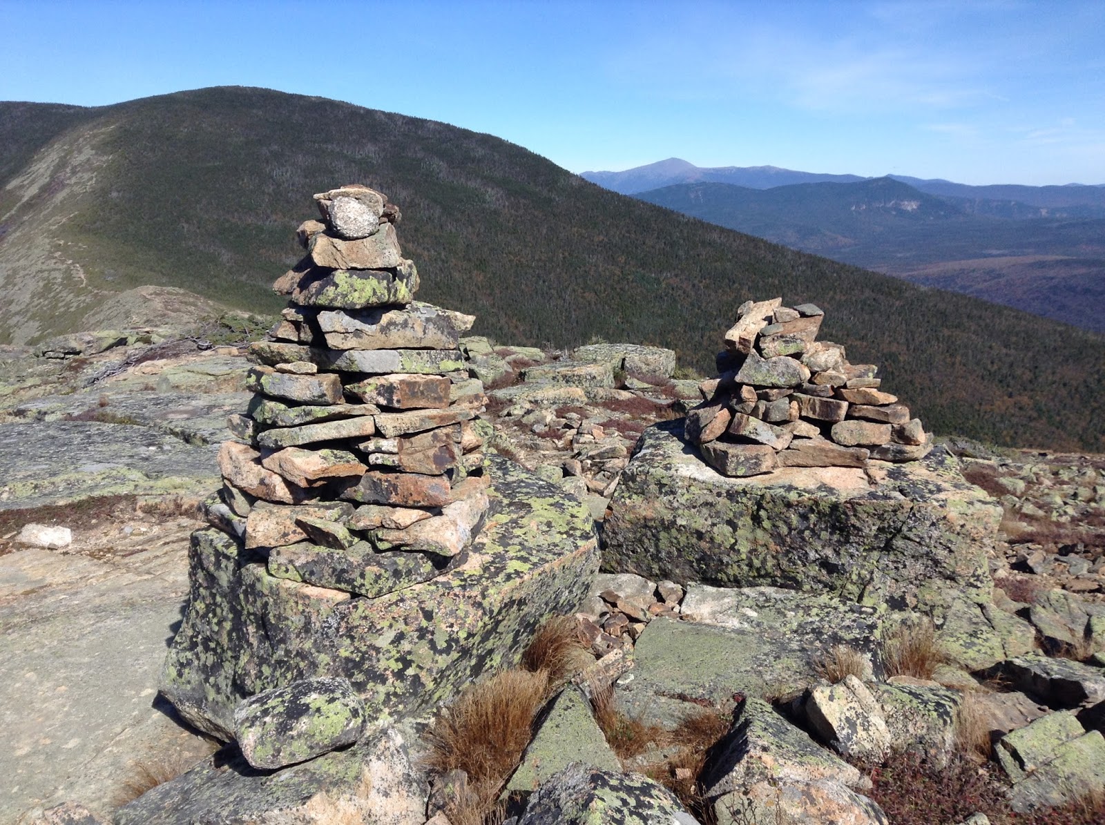 |
| Cairns |
 |
| View from Mt Bond - Washington and the Presidentials in the background |
With my tent set up I ventured back up the trail to tag West Bond and enjoy the sunset over Franconia ridge. I mistimed it badly and had to spend 45 minutes up there before it set. But the views were enchanting and my synthetic coat kept me warm. It also gave me time to reflect. Then I returned to the darkening camp and made dinner in the "kitchen" using my whisperlite stove and one of those rehydrated backpacker meals (Beef Pho - good!) With my belly full and complete darkness achieved at 7:30 PM I decided to turn in since it was going to be a cold night (28 degrees!) I can't say I slept all that well. I woke up every hour or so due to the cold and used some well placed hand warmers to keep my feet warm. But overall I wasn't freezing and got a decent amount of rest.
I awoke at 6 AM as the first drops began to hit my tent. I supposed I could have pulled up shop right away to avoid a wet tent but I was in no mood to rush. Instead I cooked some breakfast (okay, I boiled water and poured it into a bag) and then spent a relaxing hour under the porch of the shelter, chatting with an older fellow who clearly has done a ton of backpacking over the years. He and his son were also doing the Pemi Loop but as I set out their plan was to head for the 13 Falls Campsite instead. I packed up under the cover of the shelter and by 9:30 AM made my way out into the steady drizzle. While my start time was similar to yesterday, I didn't realize I was in for a longer day.
 |
| A long way from anything except the campsite |
 |
| The Guyot Campsite Shelter |
 |
| The "kitchen" (the tarp was helpful in the morning) |
 |
| The spring was conveniently right next to the kitchen |
 |
| Going into this trip I was nervous about bears and these signs did not help. Glad to use the bear box rather than attempt to hang my food though. |
 |
| I had my pick of the tent platforms |
 |
| A very successful Day 1 |
The trails were flooded, almost all had standing water or streams. I was moving slow but I was comfortable and the 50ish temp was no issue. The wind above treeline was intense and nearly blew me over at times. The summit of South Twin was crazy-windy and I was already feeling the effects. From last year's trip I knew that it was a steep descent to the Galehead Hut and it took me a while to make my way down the slippery rocks. I could hear the hut's windmill going crazy and I arrived at the hut two hours after I left the campsite, wet and with shaky legs.
I anticipated baked goods at the hut and I ate them (coffee cake and a mint chocolate bar). The place was empty save for a couple kids playing checkers and a few croo members cooking. Outside the weather vane was howling and a glance at the weather forecast predicted 65-90 mph gusts late in the day. It was 6.6 miles from the hut to the summit of Mt Lafayette. I was going to have to reach that and then descend a mile to get to the Greenleaf Hut. It felt very far away and much of my clothes were already quite wet. I found their AMC Guide and began to read trail descriptions, feeling nervous about the journey ahead and worrying about wet clothes, food and conditions near the summit. There would be about two miles of exposed trail that I would have to traverse on Lafayette. Finally after 40 minutes of hemming and hawing I decided I had to press on. Rob was going to meet me in the morning and I frankly had planned to eat the dinner/breakfast at Greenleaf so my foodstores were slim. I would venture forth and if necessary, I could stop at the Garfield Ridge Shelter or take one of the trails out of the mountains.
The rain had pretty much stopped when I left the hut but the trails were still very wet. The Garfield Ridge Trail is long with many short steep ascents and descents which made for slow going. Not for the first time I thought about how amazing it is that some cats can do this entire loop in just over six hours. Despite the dampness I was very comfortable. Anytime I stopped I could feel the chill wanting to come on so I kept moving as best I could. The climb up towards Garfield featured a very steep section with lots of scrambling. I took a brief detour to the Garfield Ridge Shelter to check it out and sign their log book but I knew I'd be continuing on. I was tired but otherwise in good spirits. Another brutal climb was in store before I reached the summit of Garfield. Very high winds were present, as well as a group of five guys, smoking cigarettes and preparing to head to Galehead for the night.
 |
| Garfield Ridge Shelter (built in 2011) |
 |
| This was as dry as the trails got |
 |
| Tired but nearing the alpine zone of Lafayette |
 |
| The Alpine sign I'd been waiting for. Getting close! |
 |
| At the summit of Lafayette, exhausted but happy |
 |
| My destination, the Greenleaf Hut, shrouded in fog |
From here it was a true slog of three miles on up and downs along very wet trails. Other than those Garfield smokers, I would see no one all day. A light rain began to fall. My pack began to feel really heavy. I would trudge along and take breaks when it felt necessary. Then the endless climbs to Lafayette began in earnest. I was very happy to see the sign for the alpine zone as it meant I was finally close (or closer, I suppose). Once I got above treeline, I was energized because it's so cool up there, even in the heavy fog. But the fog disguised several false summits which grew dispiriting after awhile. And as I went higher, the wind became more powerful. Still I was close now and motivated. I reached the summit around 4:20 and shouted for joy! But I still had another mile of slippery descent to the hut. Would I get there by 5 PM? Was dinner at 5 PM? The thought of missing dinner was horrifying.
When the heard the manic weathervane of Greenleaf I was beyond happy. I emerged into a packed hut filled with comfortable people chitchatting and playing games. I looked wet and haggard (several people confirmed this later). After checking in (dinner was at 6 PM, yay!) I went to claim my bunk and get into dry clothes. Unfortunately a great deal of my garb was wet. The bunkroom was in the 40s and was only going to get colder. There would be no drying tonight. Pretty much everyone at the hut was in the same boat with regards to wet clothes. Thankfully I still had enough dry stuff to wear and my synthetic jacket survived the journey unmolested. I enjoyed a hearty dinner and played cards for a couple hours with some funny folks before retiring for a mediocre night's sleep.
We awoke to a frozen landscape. Snow and frost covered the outside world and the summit was hidden behind grey clouds. The weather report indicated that there were heavy winds at the summit with potentially a -5 degree windchill. They weren't sure when the cloud cover would break. We all enjoyed a filling breakfast but no one was in any hurry to leave the hut. The volunteer trail steward who was supposed to head up to the ridge for the day opted to stay at the hut and recommend to hikers to avoid heading to the summit. Much of my gear was still wet and my expectations were low. At this point I had pretty much given up on completing the loop but was hoping to still do much of the ridgeline. Now I wasn't sure of even that.
 |
| My friend Rob, aka the Manchild |
 |
| I picked up this REI jacket on clearance a couple weeks back. It was a lifesaver on this trip and kept me very warm. |
 |
| The top 2000 feet were frost and ice |
 |
| Powerful winds buffeted us as we neared the top |
 |
| The summit sign is a little harder to make out a day later |
 |
| We made it! |
Then my friend Rob suddenly appeared. He strove in through the kitchen, wearing a raincoat and shorts. I think he shocked people. Well he's a shocking man. With his arrival I knew we would at least try for the summit of Lafayette. Buoyed by his energy, I packed up my gear, bought a dry hat from the hut store and we set out. It wasn't too bad under the cover of trees but once we made it about 1/3 of a mile we felt the full effects of the wind. The rocks with snow provided some traction but there were many covered in ice that were very treacherous. It was a slow climb and the wind was very powerful. Finally after about an hour we reached the summit. There were a couple folks already up there. Once we got up there I made the decision that we should head back down rather than tackling the ridge. I was wearing my old Cascadias and while they were performed dutifully up to this point (even in yesterday's rainfest) I could feel my feet begin to get cold and I was very nervous about almost two miles of exposed ridge in these conditions. Rob hesitantly agreed and we descended.
There was a steady train of folks that we passed, most of whom had stayed at the hut last night. After about fifteen minutes of descending, the clouds finally cleared and we were afforded incredible views of the ridge and valley. Curses! We should have done the ridge after all. Rob was really bummed and so was I but I know it was the right call at the time. We returned to the hut which was now mobbed with people. Day hikers had packed the place in our absence. Still wanting to hike, we decided to take the Greenleaf Trail down and perhaps hike up Cannon Mountain instead.
 |
| The views finally came 15 minutes too late |
 |
| Our great regret: not attempting the ridgline to Mt Lincoln |
 |
| Cool rocks on the Greenleaf Trail |
 |
| 2.5 miles of flatness to go |
After Rob dropped me off I ended up doing another couple miles of easy hiking along the Pemi River in the hopes that the traffic towards Lincoln would ease up. It didn't and as the sun set I joined the masses for the slow ride to my motel. But I didn't care. At this point I was exhausted and completely pleased with my journey. I didn't complete the loop as I had planned but between the weather and the state of my legs I have no complaints. Overall I was happy with the gear I brought and learned a few lessons for next time. Four more peaks are now checked off my 4000 footer list which brings my total to thirty (eighteen to go). Looking forward to my next adventure!
 |
| Until next time New Hampshire |
Subscribe to:
Posts (Atom)